RHESSys is a GIS-based, hydro-ecological model which has been developed to simulate water, carbon and nutrient flux cycling and transport in watersheds (Tague and Band 2004). RHESSys combines both a set of physically based process models and a methodology for partitioning and parameterizing the landscape.
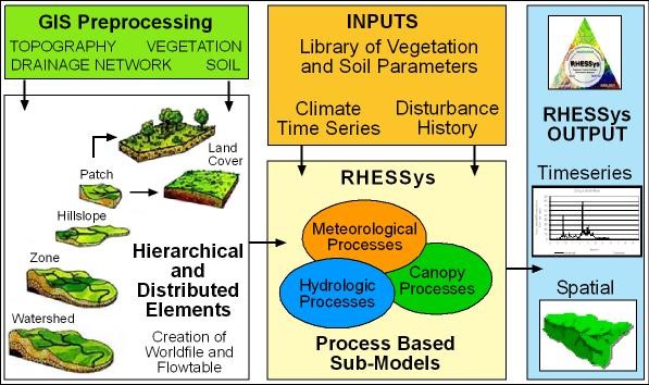
THE MODEL IS DESIGNED AS A SPATIALLY NESTED HIERARCHICAL REPRESENTATION OF THE LANDSCAPE, USING DIFFERENT MODELS TO REPRESENT PROCESSES AT DIFFERENT SCALES.
RHESSys (Band et al., 2000; Band et al., 1993; Tague & Band, 2004) is a physical process-based model, which integrates hydrologic processes, biogeochemical cycling and 4 microclimate variability using the algorithms modified from the several existing models: TOPMODEL (Beven & Kirkby, 1979), BIOME-BGC (Running & Hunt Jr., 1993), and MTCLIM (Running et al., 1987). The Geographic Information System (GIS)-based model framework of RHESSys allows it to directly import remote sensing data to describe the spatial information such as land cover, soil type, leaf area index (LAI), and topography as digital elevation model (DEM).
Current Modelling Projects:
Shabnam Rouhani, UMass Boston:Assessing the role of climate change and land use change scenarios with Eco-hydrologic modeling(Snowmelt timing and Dissolved Organic Carbon fluxes).
Past Research from SpectralMass Group Members:
Yun Yang, UMass Boston, 2013:Studying Soil Moisture and Land-to-Water Carbon Export in Urbanized Coastal Areas Using Remotely Sensed Data and a Regional Hydro-Ecological Model.
Jihyun Kim, Boston University, 2015:Carbon and Water Cycles in Mixed-Forest Catchments: Ecohydrological Modeling of the influence of Climate Variability and Invasive Insect Infestation.
Citations
Tague, C.L., & Band, L.E. (2004). RHESSys: Regional Hydro-Ecologic Simulation System-An Object-Oriented Approach to Spatially Distributed Modeling of Carbon, Water, and Nutrient Cycling. Earth Interactions
Band, L.E., Patterson, P., Nemani, R., & Running, S.W. (1993). Forest ecosystem processes at the watershed scale: incorporating hillslope hydrology. Agricultural and Forest Meteorology, 63, 93-126
Band, L.E., Tague, C.L., Groffman, P., & Belt, K. (2001). Forest ecosystem processes at the watershed scale: hydrological and ecological controls of nitrogen export. Hydrological Processes, 15, 2013-2028
Beven, K., & Kirkby, M.J. (1979). A physically based, variable contributing area model of basin hydrology. Hydrological Sciences, 24, 43-69
Running, S.W., Nemani, R.R., Heinsch, F.A., Zhao, M.S., Reeves, M., & Hashimoto, H. (2004). A continuous satellite-derived measure of global terrestrial primary production. bioscience, 54, 547-560
Hayhoe, K.; Wake, C.P.; Huntington, T.G.; Luo, L.; Schwartz, M.D.; Sheffield, J.; Wood, E.; Anderson, B.; Bradbury, J.; DeGaetano, A.; Troy, T.J.; Wolf, D. 2007. Past and future changes in climate and hydrological indicators in US Northeast. Climate Dynamics.
Hodgkins, G. A., R. W. Dudley. Trends in Streamflow, River Ice, and Snowpack for Coastal River Basins in Maine During the 20th Century. U.S. GEOLOGICAL SURVEY: Water-Resources Investigations Report
Kolka RK, Grigal DF, Verry ES, Nater EA (1999) Mercury and organic carbon relationships in streams draining forested upland peatland watersheds. Journal of Environmental Quality 28: 766775
Sarah E. Gergel, Monica G. Turner, and Timothy K. Kratz. (1999). Dissolved Organic Carbon as an indicator of the scale of Watershed influence on lakes and rivers
Professor Crystal Schaaf’s Lab
School for the Environment University of Massachusetts Boston 100 Morrissey Blvd.