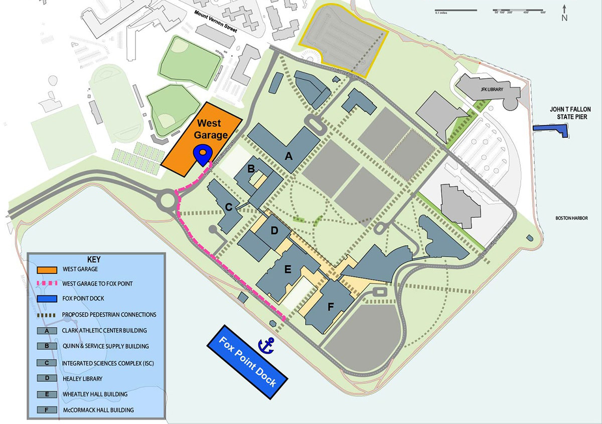
Map and Directions to the Fox Point Dock
Here are the best ways to get to the Fox Point Dock:
Public Transportation to Campus
Weekdays
Take the MBTA Red Line to the JFK/UMass station; use the free shuttle bus to get dropped off at one of two locations:
- Clark Athletic Center (#2 on the map): Take the Route 2 Shuttle to the Clark Athletic Center circle. Go up the stairs to the plaza level and walk across and into the Integrated Sciences Complex (ISC) (#6 on the map), go down one level, exit the building at the ground level front doors, and follow the yellow arrow on the map.
- Campus Center (#1 on the map): Take the Route 1 or Route 3 Shuttle to the Campus Center. From that drop-off walk up the stairs to the plaza level of campus, walk across the plaza and into the Integrated Sciences Complex (ISC) (#6 on the map), go down one level, exit the building at the ground level front doors, and follow the yellow arrow on the map.
Weekends
Take the MBTA Red Line to the JFK/UMass station; use the free shuttle bus to get dropped off at the Campus Center (#1 on the map). From that drop-off walk up the stairs to the plaza level of campus, walk across the plaza and toward Wheatley Hall on your left. Follow signs ‘TO FOX POINT DOCK’ on the building around to the left, go down stairwell #5 two levels and exit the building at the ground level; boat docks will be ahead of you across the street.
Driving to Campus
If coming to campus, drive and park in the West Garage(highlighted on map) then follow the Walking to Fox Point Dock directions below.
Walking to Fox Point Dock
The red lines on the map are pedestrian/bike paths; look for the FOX POINT DOCK on your map. Take any nearby pathway–each will lead to the HarborWalk when heading south. The docks are about a 5-10 minute walk along the HarborWalk. Watch for signage along the way. The nearest shuttle bus stop is located by the Integrated Science Complex Building (C on your map).
Drop-off for Fox Point Dock
A drop-off area is indicated by the blue ‘anchor’ symbol on the map. From here you can walk down a couple of nearby pathways, each leading to the HarborWalk.
For general directions to campus, go to Getting Here on the university website.