Harvard Forest
Harvard Forest is a well-known field station and Long Term Ecological Research site (LTER Site) run by Harvard University located in central Massachusetts.
Our lab researches the damaging effects of an insect, the Hemlock Woolly Adelgid (Adelges tsugae), on Eastern hemlock trees (Tsuga canadensis) at Harvard Forest. Hemlock Woolly Adelgid or HWA is an invasive species that is native to East Asia. This insect poses a major threat for Hemlock trees in the Eastern US, able to wipe out 90% or more of hemlock trees in a region. Climate change is warming winters in the North-East US, allowing the adelgid to spread further north than previously possible.
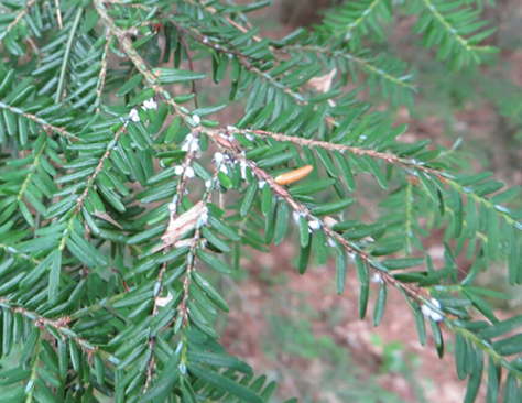
HWA lays its eggs at the base of hemlock needles. Young adelgid hatch and consume nutrients from a tree’s storage cells, which in turn kills a hemlock tree needle by needle in about a decade, depending on the local climate and the regional HWA population.
|
The eggs are visible with the naked eye. These eggs are covered by a waxy substance that appears as a cotton like substance. |
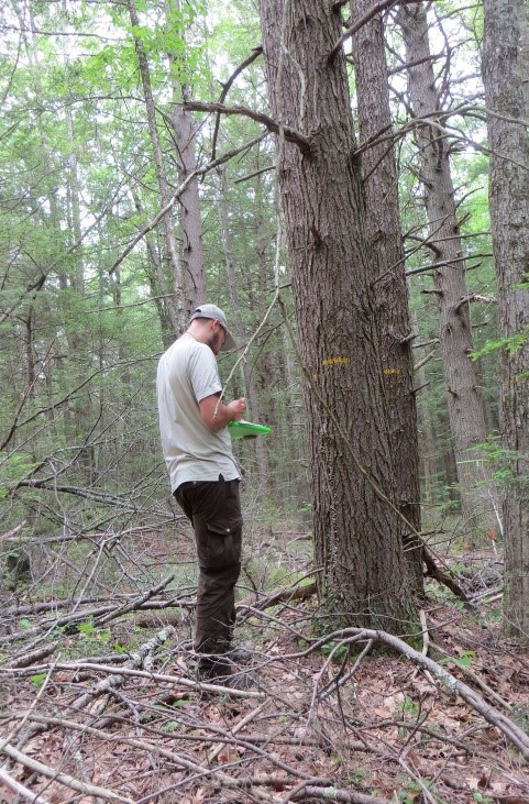
Our lab is collaborating with Dr. David A. Orwig, a Harvard University Ecologist, to quantify the loss of hemlock trees and the structural damage done to Harvard Forest. Our research is conducted in the Smithsonian Institute (SI) ForestGEO plot at Harvard Forest, aka: the MegaPlot. The plot is part of a global network of standardized forest sites. The 3.5-hectare Megaplot was established in 2010, making a record of the numerous species of trees such as birch, maple, oak, pine and hemlock. Our team assist Harvard Forest researchers by monitoring the mortality of hemlock trees through field surveys, relying on the stem map created by Dr. Orwig and his team in 2010, that tagged and labeled over 100,000 trees
|
Conducting a mortality assessment in the Harvard forest Megaplot. |
To characterize how forest structure is changing as a result of the infestation, we rely on measurements from terrestrial and airborne Lidar. Lidar instruments record information about the 3D space of the forest. Lidar data can be analyzed to model trees and derive structural parameters, such as canopy height and diameter at breast height (DBH). This 3D data can also monitor Hemlock mortality and identify structural changes such as canopy loss and new growth within forest plots.
Terrestrial and airborne Lidar provide different perspectives on forest structure. Airborne Lidar can define the top of the canopy but often misses structural information below the canopy. Terrestrial Lidar fills in the missing information by mapping out the 3D structure of the ground, the understory and midstory.
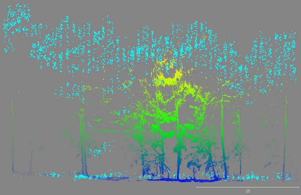
Terrestrial and airborne Lidar data has documented the structural changes in the Harvard Forest Megaplot for the last decade. Using Lidar data and collaborating with ecologists and foresters at Harvard Forest, we are able to monitor the progression of the infestation. Our ongoing work aims to use the structural information to quantify HWA’s impact on forest dynamics and on the carbon and water cycle in New England (Kim 2017).
|
An example of how airborne Lidar captures the top of the canopy structure, while terrestrial Lidar gathers information from underneath the canopy. Airborne Lidar point cloud (light blue) Terrestrial Lidar point cloud (dark blue, green and yellow) |
Data:
Terrestrial Lidar data has been collected using the CBL and airborne Lidar data has been collected annually by the Nation Science Foundation’s (NSF) NEON airborne observation program as well as NASA’s Gliht program.
Professor Crystal Schaaf’s Lab
University of Massachusetts Boston
100 Morrissey Blvd.