MCD43C2 CMG BRDF/Albedo Model Snow-Free Parameters Product
MODIS User Guide V006 and V006.1This Guide is a living document that describes the MODIS BRDF and Albedo Products. It is revised as progress is made in the development of these products. The purpose of the document is to give the potential user an understanding of the MCD43 products and the current state of the data in those products. Note: The reprocessed (V006 and V006.1) MODIS BRDF/Albedo products have been assigned a "Validated (Stage 3) Status". Users are urged to use the band specific quality flags to isolate the highest quality full inversion results for their own science applications. "Please note: the collection 6 MCD43 data has been superseded by a major reprocessing effort, collection 6.1. These data will be available from the LP DAAC, and will replace the collection 6 data. Users are strongly advised to switch to the collection 6.1 data as soon as possible. Please see the MODIS Land Team website for more information." |
The MCD43C2 Climate Modeling Grid (CMG) BRDF/Albedo Model Snow-Free Quality Parameters Product (MODIS/Terra BRDF/Albedo Snow Free Quality Parameters Daily L3 Global 0.05Deg CMG) supplies the weighting parameters associated with the RossThickLiSparseReciprocal BRDF model that best describes the anisotropy of each pixel. These three parameters (fiso , fvol , fgeo) are provided for each of the MODIS spectral bands as well as for three broad bands (0.3-0.7µm, 0.7-5.0µm, and 0.3-5.0µm) at a 0.05 degree spatial resolution in global files in a geographic (lat/long) projection. These model parameters are based on the underlying 30arcsecond model parameters. Note that along coastlines, this means that the 30 arcsecond pixels that lie over shallow water will be averaged into the 0.05 degree CMG pixel. In addition to the spectral and broadband parameters themselves, the MCD43C2 CMG BRDF/Albedo Model Parameters Product also provides extensive quality information. The quality and inversion status of the majority of the underlying 30 arcsecond pixels is provided as well as the percentage of the underlying pixels that were present. The uncertainty layer gives the quality of the full inversion from the measure of the angular sampling of input surface reflectance for the BRDF retrieval.
These parameters can be used in a forward version of the model to reconstruct the surface anisotropic effects and thus correct directional reflectances to a common view geometry (this is the procedure that is used to produce MCD43A4 Nadir BRDF-Adjusted Reflectances - NBAR) or to compute the integrated black-sky (at some solar zenith angle) and white-sky albedos (as is done for MCD43A3). Alternately, the parameters can be used with a simple polynomial to easily estimate the black-sky albedo with good accuracy for any desired solar zenith angle [1],[2]. The polynomial is as follows:
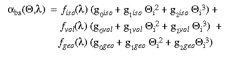
The appropriate constants are:
| Term | Isotropic (iso) | RossThick (vol) | LiSparseR (geo) |
| g0 | 1.0 | -0.007574 | -1.284909 |
| g1 | 0.0 | -0.070987 | -0.166314 |
| g2 | 0.0 | 0.307588 | 0.041840 |
Similarly, the white-sky albedo can be computed by using the equation:

and the estimates of the white-sky kernel integrals are:
| Term | Isotropic (iso) | RossThick (vol) | LiSparseR (geo) |
| White-sky integral g |
1.0 | 0.189184 | -1.377622 |
Please note: We recommend that users use the MCD43D 30 arcsecond products (or the 30 arcsecond MCD43GF gapfilled products) instead of the MCD43C products as much as possible, since the MCD43C products merely represent averages of the direct BRDF retrievals obtained with the MCD43D processing. The averaged MCD43C products thus necessarily include various QA flags within each pixel, and are therefore less rigorously high quality than the MCD43D products.
References Cited
Schaaf, C. L. B., J. Liu, F. Gao and A. H. Strahler, MODIS Albedo and Reflectance Anisotropy Products from Aqua and Terra, In Land Remote Sensing and Global Environmental Change: NASA's Earth Observing System and the Science of ASTER and MODIS, Remote Sensing and Digital Image Processing Series, Vol.11, B. Ramachandran, C. Justice, M. Abrams, Eds, Springer-Cerlag, 873 pp.,2011.
Gao, F., C. Schaaf, A. Strahler, A. Roesch, W. Lucht, and R. Dickinson, The MODIS BRDF/Albedo Climate Modeling Grid Products and the Variability of Albedo for Major Global Vegetation Types, J. Geophys. Res., 110, D01104, doi:10.1029/2004JD00519, 2005.
Schaaf, C. B., F. Gao, A. H. Strahler, W. Lucht, X. Li, T. Tsang, N. C. Strugnell, X. Zhang, Y. Jin, J.-P. Muller, P. Lewis, M. Barnsley, P. Hobson, M. Disney, G. Roberts, M. Dunderdale, C. Doll, R. d'Entremont, B. Hu, S. Liang, and J. L. Privette, First Operational BRDF, Albedo and Nadir Reflectance Products from MODIS, Remote Sens. Environ., 83, 135-148, 2002.
Lucht, W., C.B. Schaaf, and A.H. Strahler. An Algorithm for the retrieval of albedo from space using semiempirical BRDF models, IEEE Trans. Geosci. Remote Sens., 38, 977-998, 2000.
Science Data Sets
While the full MCD43C1 specification (V006 and V006.1) should be consulted for the most current description, the product includes four Science Data Sets (SDS) for each pixel in the tile. These SDSs are BRDF_Albedo_Parameter0, BRDF_Albedo_Parameter1, and BRDF_Albedo_Parameter2 representing the three model parameters fiso, fvol, fgeo for the RossThickLiSparseReciprocal BRDF model (each for bands 1-7 and three broad bands), and BRDF_Albedo_Quality.They are provided in global files in a geographic (lat/long) projection (3600 rows X 7200 columns (X 10 bands)).
Note that the V006 and V006.1 MODIS MCD43 products are retrieved daily and represent the best BRDF possible based on 16 days’ worth of inputs with the day of interest emphasized. Unlike the earlier reprocessed versions (where the date of the product signifies the first day of the retrieval period), and the Direct Broadcast version (where the date signifies the last day of the retrieval period), the date associated with each daily V006 and V006.1 retrieval is the center of the moving 16 day input window. This change is in response to user requests.
Local Attributes
In addition to the actual SDS data values produced at each pixel in a tile, each SDS is associated with a number of standard Local Attributes that apply to the data. For the BRDF_Albedo_Parameter* SDSes they include:
For the BRDF_Albedo_Quality SDS, they include:
| Name: | Type: | Value: |
| long_name | HDF-STRING | "BRDF_Isotropic_Weight (or BRDF_Volumetric_Weight or BRDF_Geometric_Weight)" |
| units | HDF-STRING | "no units" |
| valid_range | HDF-int16 | 0, 32766 |
| _FillValue | HDF-int16 | 32767 |
| add_offset | HDF-float64 | 0.0 |
| add_offset_err | HDF-float64 | 0.0 |
| calibrated_nt | HDF-int32 | 5 |
| scale_factor | HDF-float64 | 0.001 |
| scale_factor_err | HDF-float64 | 0.0 |
For the BRDF_Albedo_Quality SDS, they include:
| Name: | Type: | Value: |
| long_name | HDF-STRING | "Aggregated_Albedo_Quality" |
| units | HDF-STRING | "concatenated flags" |
| valid_range | HDF-uint32 | 0, 4294967294 |
| _FillValue | HDF-uint32 | 4294967295 |
Global Attributes (Metadata)
In addition to the albedo and quality information (SDSs and Local Attributes) that is provided at a per-CMG-pixel level, each Level 3 MCD43C2 CMG Albedo Product also Metadata which summarize the file. (See the full MCD43C2 specification (V006 and V006.1) for the complete listing.)
Professor Crystal Schaaf’s Lab
University of Massachusetts Boston
100 Morrissey Blvd.