Sediment Budget
During the 19th Century, major bathymetric/topographic surveys were undertaken to increase understanding of the physical processes acting on outer Cape Cod shores to support resource management (e.g., Graham (1835), Whiting (1857), Mitchell (1871). Notable among these, was the three-year coastal survey of H.L. Marindin (1890), extending alongshore from North Chatham to Provincetown and consisting of 240 cross-shore transects extending from terrestrial environments completely across the shoreface to deep water (c. 30 m depths).
Marindin was interested in what is today known as the coastal sediment budget; that is, in determining the directions and rates of longshore sediment, as well as locating and quantifying the sources and sinks of those flows. He intended that his work would establish a baseline that could be used by future investigators to determine volumetric coastal change.
The importance of sediment budgets and longshore sediment transport rates for developing improved management strategies along the Cape Cod coast became increasingly apparent throughout the 20th Century (U.S. Congress, 1960). Early work done on sediment budgets and littoral cells by Bowen and Inman (1966) led to gradual incorporation of these ideas into coastal management entities (Komar, 1998).
In the later 1990s, the National Park Service and Cape Cod National Seashore commissioned the Center for Coastal Studies to resurvey the Marindin transects and, from a comparison of the two surveys, Giese et al. (2011, 2015) estimated the patterns and rates of longshore sediment transport along the east-facing coast of outer Cape Cod and a short section of the west-facing coast of the Provincetown Hook (fig. 1).
Sediment budgets, where available, aid scientists and managers in understanding short- and long-term coastal evolution (Rosati, 2005). Quantitative estimates of net and/or gross sediment transport, coupled with shoreline evolution and sediment transport pathways can be the basis for comprehensive management of the shoreline (Komar, 1998). However, relative to beaches and coastal dunes, there is a lack of data on the shoreface, in part, due to the difficulty making measurements in these areas (Deng et al., 2017). The Cape Lab and the Center for Coastal Studies have continued to develop these methods to produce guidance for state and local management entries (Borrelli et al., 2015; Borrelli et al., 2017; Giese et al., 2013, Giese et al., 2018) and is currently preparing a manuscript for the peer-reviewed literature. Understanding the boundaries of littoral cells, rates and direction of net sediment transport should be the basis for science-based coastal management.
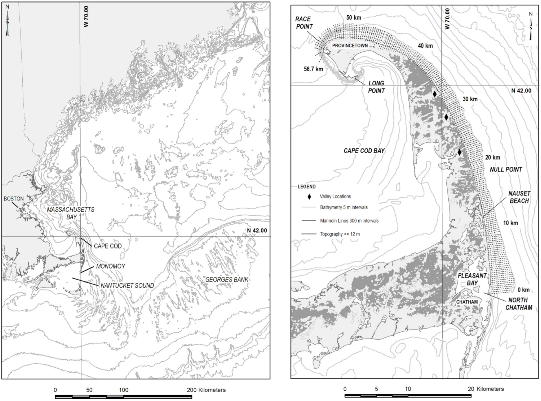
Fig.1. Cape Cod and adjacent continental margin. The study area extends from North Chatham to Race Point and includes 190 cross-shore transects.
Sources:
Borrelli, M., Giese, G. S., Mague, S. T., Smith, T. L., Legare, B., and Barger, P., 2016, Assessment of the Century Scale Sediment Budget for the Sandwich and Barnstable Coasts of Cape Cod Bay: Cape Cod Canal to Barnstable Harbor. p.38.
Bowen, A.J., Inman, D.L., 1966. Budget of littoral sands in the vicinity of Point Arguello, California. US Department of the Army, Corps of Engineers.
Deng, J., Woodroffe, C.D., Rogers, K., Harff, J., 2017. Morphogenetic modelling of coastal and estuarine evolution. Earth-Science Reviews, 171, 254-271.
Giese, G. S., Adams, M. B., Rogers, S. S., Dingman, S. L., Borrelli, M., and Smith, T. L., 2011, Coastal Sediment Transport on outer Cape Cod Massachusetts: Observations and Theory, in Rosati, J. D., Wang, P., and Roberts, T. M., eds., Coastal Sediments 2011, Volume 3: Miami, Florida, USA, World Scientific Pub Co Inc, p. 2353- 2365.
Giese, G.S., Borrelli, M., Mague, S.T., Barger, P., McFarland, S., 2018. Assessment of the Century-Scale Sediment Budget for the Eastham and Wellfleet Coasts of Cape Cod Bay. A Report Submitted to the Towns of Eastham and Wellfleet, Center for Coastal Studies, Provincetown, MA.
Giese, G.S., M. Borrelli, M., S.T. Mague, T. L. Smith, and P. Barger. 2015. Assessment of the Century Scale Sediment Budget of the Brewster Coast. Marine Geology Report No.15-X, Center for Coastal Studies, Provincetown, MA. Prepared for the Town of Brewster, MA. p.
Giese, G.S., M. Borrelli, S.T. Mague, T. Smith and P. Barger, 2014, Assessment of Multi- Decadal Coastal Change: Provincetown Harbor to Jeremy Point, Wellfleet. A Report Submitted to the Massachusetts Bays Program. January 2014. 23 p.
Giese, G.S., Borrelli, M., Mague, S.T., Smith, T.L., Barger, P., Hughes, P., 2013. Evaluating century-scale coastal change: Provincetown/Truro line to Provincetown Harbor. No. 14-1, Center for Coastal Studies.
Giese, G.S., Borrelli, M., S.T. Mague, and P. Hughes, 2012, Evaluating century-scale coastal change: a pilot project for the Beach Point area in Truro and Provincetown, Massachusetts. Marine Geology Report No.12-2, Center for Coastal Studies, Provincetown, MA, 18 p.
Giese, G.S., Borrelli, M., Mague, S. T., Smith, T. L., Barger, P., Adams, M. B., and Hughes, P., 2015, Century-Scale Longshore Sediment Transport Rates Calculated From Reconstructed Historical Coastal Surfaces, The Proceedings of the Coastal Sediments 2015, World Scientific, p. 1-4.
Graham, J.D., 1835. A map of the extremity of Cape Cod : including the townships of Provincetown & Truro: with chart of their sea coast and of Cape Cod Harbour, State of Massachusetts.
Komar, P.D., 1998. Beach Processes and Sedimentation. Prentice Hall. pp. 544.
Marindin, H.L. 1889. Cross-Sections of the Shore of Cape Cod Between Chatham and the Highland Light-House. Report of the Superintendent of the United States Coast Survey showing the Progress of the Survey during the Fiscal Year ending with June, 1889. Appendix No. 13. Government Printing Office, Washington. 1890. pp. 409-457. Mitchell, H., 1871. Report to Prof. Benjamin Peirce.
Rosati, J.D., 2005. Concepts in sediment budgets. Journal of Coastal Research. v.212. 307-322.
Thom, B.G., Eliot, I., Eliot, M., Harvey, N., Rissik, D., Sharples, C., Short, A.D., Woodroffe, C.D., 2018. National sediment compartment framework for Australian coastal management. Ocean & Coastal Management, 154,103-120.
U.S. Congress, 1960, Shore of Cape Cod between the Cape Cod Canal and Race Point, Provincetown, Mass., Beach erosion control study. House Doc. 404, 86th Congress, 2nd Session, 102 p.
Zeigler, J.M., Tuttle, S.D., Tasha, H.J., Giese, G.S., 1965. The Age and Development of the Provincelands Hook, Outer Cape Cod, Massachusetts. Limnology and Oceanography. v.10. R298-R311.